Kampong Chhnang Province, Cambodia
Introduction
The RoadMark mobile phone app was used to undertake a visual inspection of approximately 1,100km of rural roads in Kampong Chhnang Province in Cambodia for the Department of Rural Roads, over three days in February and March 2019. These surveys were used to record the inventory and condition of all the key road assets on these routes, including the carriageway, shoulders, drainage, culverts and bridges. Other specific items recorded included administrative areas, adjacent land use, the location of any community or government services and details about any other street furniture present (e.g. road signs) and earthworks.
Figure 1 shows a map of the roads surveyed, including the location of any culverts and bridges, plus the condition of these assets (colour-coded). This map (along with many others) was created using the freely available, open-source QGIS software, using the data collected by the RoadMark app. Extensive tailoring of these maps is possible, with a wide range of different information shown in different way, and specific areas can be explored in greater detail.
Figure 1:Extent and Condition of Road Assets Surveyed Using RoadMark
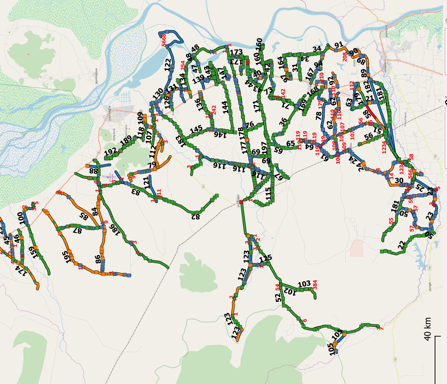
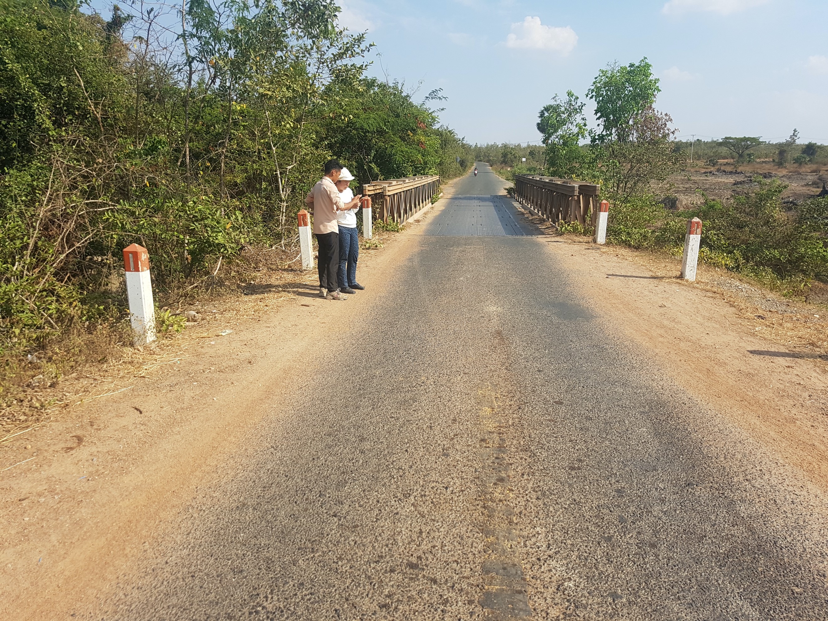
Figure 2 shows one of the surveys teams using the RoadMark app to record the road asset data. Each survey team comprised of a driver, a surveyor using the RoadMark app and a local engineer, who was familiar with the local road network. (These last two roles could easily be combined, allowing these surveys to be conducted using just one surveyor and one vehicle operator.)
The RoadMark Analysis software provides reports to allow surveys to be easily monitored, allowing progress to be easily monitored and survey durations to be estimated. Survey speeds averaged approximately 10 kph, in which all the key road assets were recorded. Greater speeds are possible by more experienced surveyors or where fewer road features are to be recorded.
Training of local surveyors was carried out on-site (any suitable road can be used) and required no more than half a day. Apart from suitable transport (cars or motorbikes), the only equipment required is an Android Smartphone with a GPS function and a copy of the (freely available) RoadMark app installed. No internet nor mobile signal is required to carry out surveys and it is not necessary for any road referencing system to be in place.
Figure 2:Surveyors Using the RoadMark App to Record Road Asset Inventory
& Condition Data
Road Assets Surveyed
A total of 1,103km of roads were surveyed of which 730km were unpaved. About 626km were deemed to be in good condition, with 194km being in a Poor condition, (mostly unpaved roads). A total of 495km of shoulders were also inspected (378km unsealed), plus 275km of side drains (approximately half of which were in a Fair condition). In addition, 1,379 culverts were inspected (amounting to a total of 5,177m of culverts), (two thirds of which were in a Good condition), plus 110 bridges, with a total deck area of 9,878m2.
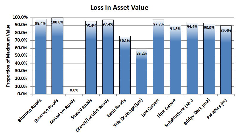
Based on the estimated treatment costs, the replacement value of these assets amounted to over $79.4 million, of which paved roads contributed approximately $37.3 million, unpaved roads a further $36.2 million and bridges and culverts approximately $6 million. Figure 3 shows the estimated replacement values of the road assets surveyed, whilst Figure 4 shows the current values of these assets, compared to their replacement values. This is a useful indicator, showing which assets are in particular need of attention. These assets were generally in fairly good condition, although side drains and earth roads appear to require particular attention.
Figure 3:Estimated Replacement Value of Road Assets Surveyed
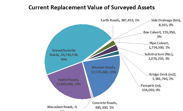
Figure 4:Current Value of Road Assets, Compared to their Replacement Values
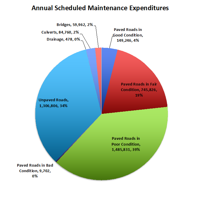
Based on the estimated treatment costs and optimum maintenance standards (required to maintain these road assets in a stable, long-term condition), the annual maintenance requirements amount to approximately $3.84 million. Figure 5 shows how these costs are comprised across the different road assets and treatment types.
Figure 5:Estimated Scheduled Annual Maintenance Cost Requirements
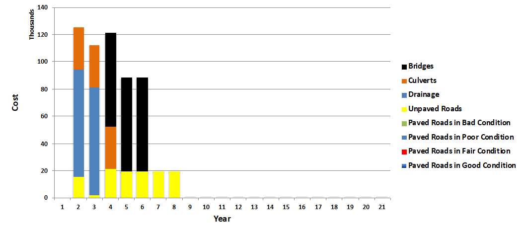
The road assets surveyed were in a generally good or fair condition, although based on the estimated optimum maintenance standards for these assets, there was a maintenance ‘backlog’ of around $574,000. Figure 6 shows how these backlog costs were distributed across the different road asset types, and how they could be cleared over a 7 year period.
Figure 6:Estimated Distribution of Maintenance “Backlog” Costs
Key Performance Indicators (KPIs)
The data collected using the RoadMark software also allowed various Key Performance Indicators (KPIs) to be estimated for those assets that were surveyed, which can be used to monitor how the road assets change over time. These KPIs included:
Estimated Current Asset Values and their Replacement Values (as a percentage)
• Proportion of Bridges and Culverts on Higher Class Roads in a Poor or Bad Condition
• Proportion of Paved Roads (by Road Class) in a Poor or Bad Condition
• An Average Condition of Paved Roads;
• An Average Condition of Unpaved Roads; and
• An Average Condition of Other Types of Road Assets.
Prioritisation
The works identified were also prioritised, based on the following policies:
• Safety to road users;
• Accessibility and connectivity;
• Efficiency (i.e. maximising economic returns from investments in the assets); and
• Road hierarchy (which higher classified roads taking precedence).
These allowed the identified works (amounting to approximately $1.2 million for the road assets surveyed in this case) to be prioritised by type of works across the road assets.
Sensitivity Testing
The actual costs for different types of treatments, and their impacts (e.g. durations) cannot be known for certain, so road managers should carry out sensitivity tests on the estimates that they use, to see which ones have a particularly important impact on the overall budget requirements. This helps to provide greater confidence in their strategic plans and budget estimates prepared.
For more information about how the RoadMark road data collection system could help you better manage road assets, please contact us.